Report on the "DIG" Trout Hollow 1999

The full report was prepared by Material Culture Management Inc under Ontario Archaeological License Number 99-042. The principal investigators were J. Molnar, H. Henderson, J. Fisher. For detailed information call Material Culture Management Inc. at 905 525 1240.

The Canadian Friends of John Muir wrote this abridged report
  FIELD INVESTIGATIONS
Work Began on June 1 1999 with transit survey, setting out grids, and tying the two sites to be investigated at Trout Hollow together.
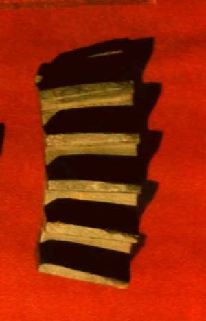
 

 SITE 1 The Mill
The mill's foundation was immediately visible and three sides of the mill were exposed and mapped on a scale of 1:10. A scatter of brick was found between the stone foundation and the mill dam. None of the bricks were charred so they were not likely from a chimney. The dam and millrace were mapped. A mound on the northeast corner of the mill was probed for 30cm with a stiff wire. The lack of resistance suggests this may have been a sawdust pile.

Among the items found on the surface was a fragment of a large steel bevel wheel, which helps confirm the location of the mill. Toothed bevel wheels are used with shafting in large power transmission systems with a second similarly shaped gear wheel to transfer power perpendicularly. The fragment found at Trout Hollow is 5cm wide and 13 cm long but radically broken at both ends. The gear cogs are spaced at 1 cm intervals and are 1.3 to 1.5 cm deep.

Only one of the bricks was analyzable, as all others were too highly broken up. The brick had been surface collected from the mill area being 10.7 X 6 cm half, red hand moulded with a hand impressed small frog depression one side. Hand moulding of bricks was common in Ontario until the late 19th century.

Both the steel bevel and the bricks could be associated with either the Trout's mill or the later short-lived Pleasant Valley Grist Mill.


 SITE 2 The Cabin
Activities at the cabin site included the collection of artifacts eroding down the river bank, excavation of two units on the river bank in search of privy structures, and the excavation of three units in the cabin area to confirm its location and size. Units were 1 m2 and were hand excavated with trowels. All materials were screened through a 6mm mesh.

The Privy Area
The Canadian Friends of John Muir (CFJM) had found some artifact scatter and the site and interpreted vegetative cover as a possibly privy site. Identification of the vegetation as caryx eburnea, which grows on impoverished soil and the shallow depth of soil suggest that this was not a site for a privy

The Structure Area
A scatter of mortar was noted on the ground surface, hypothesized to be the center of the structure, and related to the stove or chimney as shown in Muir's sketch of the cabin. Three units were opened to investigate the structure. Two were placed above the mortar patch. One other unit was placed in an attempted o find a corner of the structure. Nothing of any archeological significance was found in this last unit and is inferred to be outside the structure altogether. Wooden strips on either side of the mortar patch may have been floor joists and could suggest the orientation of the structure, although this interpretation is tentative. No cobbles have been found from the cobbled gables described by William Trout (1917:104).


 ARTIFACTS
A total of 223 artifacts from the site known as Trout Hollow No.2 were analyzed. These are catalogued in the table below at bottom of this page.

The two river bank area units produced the largest number of in situ artifacts. It appears to represent a more active activity area or midden. Both areas contained ceramics, bottle and window glass, nails and a clay smoking pipe fragment. These artifacts conform to 19th century origins


SUMMARY

The two river bank area units produced the largest number of in situ artifacts. The site appears to represent a more active activity area or midden. Both areas contained ceramics, bottle and window glass, nails, and a clay smoking pipe fragment. These artifacts conform to 19th century materials.


The artifacts confirm the presence of at least one structure on the structure site and dating between 1850 and1880, correlate with the known dates of occupation of the cabin and either of the two mills.

The mill location is confirmed by the 1858 map. The cabin location is almost certain, suggested by the 1858 map and it is at least a structure dating to the Trout era. If not the cabin, it may be a stable building although that is unlikely given the range of artifacts recovered from that site.

NOTE A detailed summary of the ceramic types, dates and frequency is available from the authors

   TABLE
 FUNCTION  Privy Area  River bank  Structure  Indeterminate  TOTALS

 Architecture

nails

window glass

const material


34

7

1


1


3

7

5


1


39

14

6

 Foodways

ceramic ware

ceramic use

glass bottles

glass container

tablespoon


29

15

4

3


20

5


2

1


39

5

1

2


7


95

20

1

7

1

 Clothing

fastener

bead


1

1


 Personal

mirror frag


1


1

 Smoking

pipe bowl frag


1


1


1

 Unassigned

cast iron frag

tubing

brick/crock frag


1

1

3


1

1

1

 Faunal Bone  13  1  2    16

 Medical

glass container


1


1

 20th C

fishing

hunting

picnicing


1

4

8


1

4

6